Magnetic Declination & Grid Convergence
 |
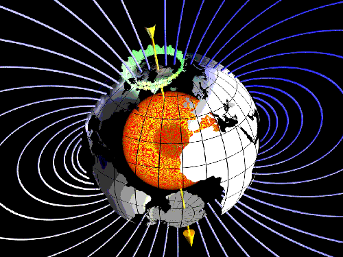
| Courtesy of GeoForschungsZentrum (Geo-Research Centre), Potsdam |
It is generally believed that a compass-needle points towards the North Pole and that the vertical grid-lines on maps like Ordnance Survey maps do likewise. Sadly, while both these beliefs are approximately true, neither is exactly so. The discrepancies are very small (no more that a few degrees in either case), but they must be taken into account for accurate position-finding and navigation.
The Earth behaves as though there were a huge bar-magnet embedded deep in its core with the "north pole" somewhere under Antarctica and its "south pole" somewhere under the extreme north of Canada. Does that sound upside down? Well it isn't—if the "north poles" of two bar magnets are brought close together, they repel each other; the south pole of one magnet attracts the north pole of another. The north pole of a compass-needle points (approximately) towards the Earth's North Pole, so the Earth is behaving as though the imaginary magnet embedded in its core has its "south pole" in the Arctic and its "north pole" in the Antarctic.
The Earth's magnetic field has two "poles" where the direction of the field is vertical; the North Magnetic Pole is located in the extreme north of Canada and the South Magnetic Pole is in Antarctica. The positions of the magnetic poles are not fixed: the Magnetic North Pole is slowly drifting north-westwards across the Canadian Arctic; the most recent survey established its position in 2001 as 81.3°N, 110.8°W and it is moving about 0.3−0.4° northwards and 0.9° westwards per year. The Geological Survey of Canada estimated its position in 2005 as 82.7°N, 114.4°W. The South Magnetic Pole was found to be at 64.7°S, 138.0°E in 2001. It's immediately obvious from these figures that the Earth's magnetic axis does not coincide with its axis of rotation; in fact, the angle between the rotational axis and the line joining the 2001 Magnetic Poles is almost 15°. But what's more surprising (although less obvious unless you happen to be very good at three-dimensional coordinate geometry) is that the magnetic axis does not even pass through the Earth's centre, but misses it by about 1300km (roughly 800 miles). Click here to see the maths.
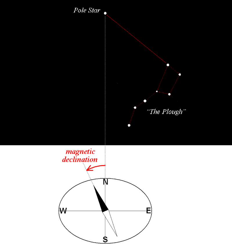
Since the magnetic lines of force are directed towards the magnetic pole, that is the direction indicated by the needle of your compass (although the magnetic field is subject to distortions caused by local topology and is also affected by the magnetic field of the "solar wind"). The angle between the compass-needle and true north is called the magnetic declination, or magnetic variation. The magnetic declination varies from place to place, and also changes slowly with time. In locations where the needle of a compass points to the west (left) of true north the magnetic declination is negative; where the compass-needle points to the east (right) of true north the magnetic declination is positive.

For detailed information about the Earth's magnetism, please see the websites of the British Geological Survey or the NGDC (U.S. National Geophysical Data Center).
The Ordnance Survey have a great deal of explanatory information on their website about their maps and the Transverse Mercator Projection they use. There is an interactive guide that explains the grid referencing system in very simple language and a two-sided A4 leaflet that they suggest you print and keep for handy reference, as well as an excellent online section about the National Grid map reference system. For the more technically-minded, an Ordnance Survey information booklet entitled A guide to coordinate systems in Great Britain is also available on their website.
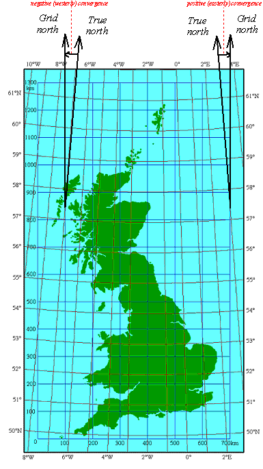
The online National Grid map reference system pages include a diagram (on page 7) similar to the one below, showing the relationship between the graticule (i.e. the lattice of intersecting meridians of longitude and parallels of latitude) and the National Grid's lattice of vertical and horizontal grid-lines and it is immediately apparent from this that the only North-South grid-line that actually points to "true north" is the one that coincides with the longitude meridian 2°W, in the centre of the projection; all the other meridians of longitude converge towards the North Pole and "grid north" is west of true north in the west half of the projection and east of grid north in the east half of the projection. The angle between the North-South grid-line and true north at any point is called the grid convergence and this is described on page 18 of the online National Grid map reference system section; page 19 gives an approximate method of calculating it (more accurate results can be obtained by using the formulae given in the now out-of-print Ordnance Survey booklet Transverse Mercator Projection: Constants, Formulae and Methods that was published in March 1983). Strangely, the much more technical A guide to coordinate systems in Great Britain doesn't mention convergence at all.

To summarise:
The magnetic declination and the convergence can both be positive or negative: positive values are east of true north and negative values are west of true north. The simplest case is where both are positive; this is shown diagrammatically in Figure 1:
 |
| Fig.1:Convergence and magnetic declination |
We can see from this that the magnetic grid variation (the angle between magnetic north and grid north) is given by
magnetic grid variation = magnetic declination − convergence
In fact, the magnetic declination is negative (that is to say, magnetic north is west of true north) throughout the British Isles at the present time, but the National Grid convergence can be either negative or positive, as I have already explained. The situation to the west of the central meridian of the Ordnance Survey projection (longitude 2°W) is shown diagrammatically in Figure 2, and the situation to the east of the central meridian is shown in Figure 3:
 |
 |
| Fig.2: In the western half of the O.S. projection, convergence and magnetic declination are both negative | Fig.2: In the eastern half of the O.S. projection, convergence is positive and magnetic declination is negative |
The relationship
still holds, though, provided the signs are handled correctly. For example, in the part of North London where I live, the magnetic declination is −2°25' and the convergence is +1°25': the magnetic grid variation here is therefore
(−2°25') − (+1°25') = −(2°25' + 1°25') = −3°50',
i.e. magnetic north is 3°50' west of grid north. On the other hand, at Penzance in the extreme south-west of Cornwall, the magnetic declination is −4°13' and the convergence is −2°43'; so the magnetic grid variation there is
(−4°13') − (−2°43') = −4°13' + 2°43' = −1°30',
so that magnetic north is 1°30' west of grid north.
| Larry Simons 23rd May 2005 |